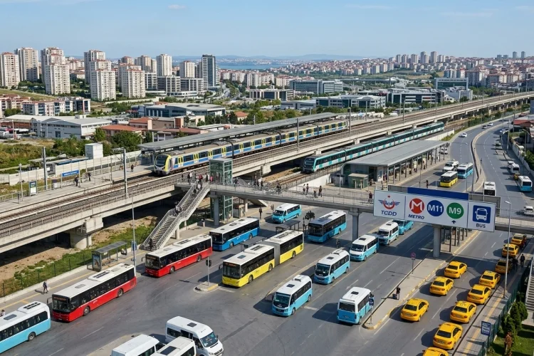
Halkalı may look like one compact neighbourhood on a map, but getting around it can be more complicated than expected.
The name is used for a wide urban area that includes Halkalı Merkez, Atakent, İstasyon, and several residential and commercial zones within Küçükçekmece. The good news is that Halkalı has become one of western Istanbul’s most useful transport hubs.
Marmaray connects it with the historic centre and the Asian side, the M11 provides access to Istanbul Airport, and the M9 serves residential areas around Atakent and İkitelli. Local buses, taxis, and minibuses fill the gaps between rail stations.
This guide explains how to get around Halkalı without wasting hours on unnecessary transfers. It covers the main railway and metro services, local buses, payment methods, and practical routes for first-time visitors.
The most important lesson is simple: always check the full station name, because several different stops include the word “Halkalı.”
Understand the Layout of Halkalı First
Halkalı is not designed like a traditional town centre where you can reach every important place on foot. Apartment developments, railway infrastructure, large roads, shopping areas, and local neighbourhoods are spread across a considerable distance.
The main Halkalı railway station is located in the İstasyon area. It serves Marmaray, the M11 airport metro, and national or international railway services. However, Halkalı Caddesi and Atatürk Mahallesi are separate stations on the M9 metro line.
This distinction is particularly important when booking accommodation. A hotel advertised as being “near Halkalı” may require a bus or taxi to reach the main station.
Save the exact address and nearest transport stop before leaving your hotel. Checking the walking route is also useful because railway tracks, highways, and gated residential complexes can make a short straight-line distance surprisingly inconvenient.
Use Marmaray for Central Istanbul and the Asian Side
Marmaray is usually the most useful service for visitors travelling between Halkalı and central Istanbul. Halkalı is the western end of the cross-city suburban railway, which runs beneath the Bosphorus and continues to Gebze on the Asian side.
The complete Halkalı-Gebze route covers 75.7 kilometres and has a scheduled end-to-end journey time of approximately 108 minutes. Most visitors will only use a section of the line rather than travel its entire length.
1. Reaching the Historic Peninsula
Take Marmaray from Halkalı toward Sirkeci when visiting Istanbul’s historic centre. Sirkeci places you within walking distance of the Spice Bazaar and close to tram connections for Hagia Sophia, Topkapı Palace, the Blue Mosque, and the Grand Bazaar.
Yenikapı is another useful transfer station. From there, passengers can connect with metro lines serving areas such as Taksim, Şişli, Aksaray, and Istanbul’s main intercity bus terminal.
2. Travelling to the Asian Side
Stay on Marmaray through the Bosphorus tunnel to reach Üsküdar. This is a convenient option for waterfront walks, ferry connections, restaurants, and views of Istanbul’s European skyline.
The line continues toward Ayrılık Çeşmesi, Söğütlüçeşme, Bostancı, Pendik, and Gebze. Check the direction displayed on the platform before boarding, as Halkalı and Gebze are opposite endpoints.
Take the M11 Metro to Istanbul Airport
The M11 Gayrettepe–Istanbul Airport-Halkalı line provides a direct rail connection between Halkalı and Istanbul Airport.
The June 2026 Metro Istanbul network map shows Halkalı as the western terminus, with the route passing through locations such as Olimpiyatköy, Kayaşehir, Arnavutköy, Taşoluk, and the airport before continuing toward Gayrettepe.
This is generally the most predictable airport option because it avoids Istanbul’s road congestion. It is especially useful during weekday rush hours or when travelling with a fixed flight schedule.
Check the latest operating hours before an early-morning or late-night journey. Do not assume that metro service runs around the clock, and allow additional time for walking through the airport terminal.
Using the M11 for Northern Istanbul
The airport line is not useful only for flights. Its connections can also help passengers reach Başakşehir, Olimpiyat, Kağıthane, and Gayrettepe.
At Gayrettepe, travellers can transfer to the M2 line for areas such as Şişli, Taksim, and Yenikapı. This can be a useful alternative when Marmaray does not suit your exact destination.
Use the M9 for Atakent, İkitelli, and Ataköy
The M9 Ataköy–Olimpiyat line is valuable when travelling within the broader Halkalı and İkitelli corridor. It serves 14 stations, including Halkalı Caddesi, Atatürk Mahallesi, Bahariye, MASKO, İkitelli Sanayi, Yenibosna, and Ataköy.
Halkalı Caddesi and Atatürk Mahallesi are particularly useful for visitors staying in Atakent. These areas contain residential complexes, cafés, supermarkets, parks, and accommodation, but they are not beside the main Halkalı railway station.
The M9 also provides several useful connections. At Ataköy, passengers can transfer to Marmaray; Yenibosna offers access to the M1A; and İkitelli Sanayi connects with the M3.
The line therefore helps travellers move between western Istanbul’s residential, industrial, and commercial districts without relying completely on buses.
Before boarding, confirm whether your destination is closer to Halkalı Caddesi, Atatürk Mahallesi, or Halkalı railway station. Confusing these names is one of the most common transport mistakes in the area.
Use IETT Buses for Local Neighbourhood Journeys
Rail lines cover the main corridors, but buses are often necessary for the final section of a journey. IETT routes connect Halkalı Station with Atakent, hospitals, residential developments, shopping areas, and neighbouring parts of Küçükçekmece and Başakşehir.
For example, route-search information includes services linking Atakent and nearby residential areas with Halkalı Marmaray. Routes and departure times can change, so use the official IETT journey planner or check live information at the stop rather than depending on an old travel blog.
The H-3 Airport Bus
The H-3 express bus operates between Halkalı Marmaray and Istanbul Airport, serving stops around Atakent, MASKO, and İkitelli. The published one-way journey time is approximately 108 minutes, although real travel time can vary with traffic.
The H-3 can be useful when the metro is unavailable or when its stops are closer to your accommodation. However, rail is normally easier to predict when road congestion is heavy.
Local buses may become crowded during commuter periods. Board with your Istanbulkart ready and move away from the doors when carrying luggage.
Know When to Walk, Take a Taxi, or Use a Minibus
Walking is practical within small sections of Halkalı, particularly around local shopping streets or residential centres. It is less convenient for moving between Halkalı Merkez, Atakent, the main station, and the Basın Ekspres corridor.
Large roads and widely spaced developments can turn what appears to be a short journey into a tiring walk. Use pedestrian directions rather than relying only on the distance shown by a map pin.
Taxis are useful for hotel-to-station transfers, late arrivals, and trips with heavy luggage. Ask the driver to use the meter, follow the route on your phone, and provide the full destination name rather than saying only “Halkalı.”
Minibuses and shared vehicles operate on some local corridors, but their routes can be harder for first-time visitors to understand. They are better suited to travellers who know the stop name or can confirm the route with a local resident.
Pay for Transport with Istanbulkart
An Istanbulkart is the most practical payment option for public transport. It can be used across much of Istanbul’s metro, Marmaray, bus, tram, and ferry network.
Cards and limited-use tickets are available through Istanbulkart’s official system. Visitors can also consider the Istanbul City Card, while the Istanbulkart mobile application supports QR-based public transport payments.
Buy or top up your card before joining a busy platform queue. Ticket machines generally offer language options, but keeping small notes or a bank card available can make reloading easier.
Fares are updated periodically, and some longer rail journeys may follow distance-based charging rules. Check current information at the station rather than relying on a price quoted months earlier.
Plan Simple Routes Before Leaving
For Sultanahmet, take Marmaray to Sirkeci and continue on foot or by the T1 tram. For Taksim, travel to Yenikapı and transfer to the M2.
For Üsküdar, stay on Marmaray through the Bosphorus tunnel. For Istanbul Airport, use the M11 from Halkalı or consider the H-3 bus when its stops are more convenient.
Travellers heading to Mall of Istanbul can use the M9 toward MASKO–Mall of Istanbul. Those staying around Atakent should identify whether Halkalı Caddesi or Atatürk Mahallesi is the nearest M9 station.
Allow extra time for transfers, especially during the morning and evening rush. Check live service announcements before important airport or railway journeys, as maintenance and temporary disruptions can affect routes.
Getting around Halkalı becomes much easier once you understand that its similarly named stations serve different parts of the area.
Marmaray is the best choice for central Istanbul and the Asian side, while the M11 connects Halkalı with Istanbul Airport. The M9 is useful for Atakent, İkitelli, Ataköy, and nearby commercial districts.
Buses provide important local connections, while taxis are practical for luggage and short transfers. An Istanbulkart makes paying for most public transport straightforward.
Before each journey, check the full station name, review live departure information, and leave extra time for walking or transfers. Save your key routes now, and you will be ready to explore Halkalı and the rest of Istanbul with far less stress.